This page is designed for browsing Newton's Geographic Information System (GIS).
THE CITY OF NEWTON'S MAPS AND ASSOCIATED DATA ARE PROVIDED WITHOUT WARRANTY OF ANY KIND AS TO THE CONTENT, SEQUENCE, ACCURACY, TIMELINESS OR COMPLETENESS OF ANY OF THE DATABASE INFORMATION. THE CITY OF NEWTON SHALL ASSUME NO LIABILITY FOR:
1. ANY ERRORS, OMISSIONS, OR INACCURACIES IN THE INFORMATION PROVIDED REGARDLESS OF HOW CAUSED; OR
2.ANY DECISION MADE OR ACTION TAKEN OR NOT TAKEN IN RELIANCE UPON ANY INFORMATION OR DATA FURNISHED HEREUNDER.
City departments will not necessarily approve applications based solely on GIS data. Applicants for city permits must inquire of the relevant city department for applicable requirements.
Click on a propery to see assessing and permitting information.
Scroll down the information box to see historic information and a list of the inspectors
Use the box on the upper left to search for an address
The "Layers" dropdown in the upper right allows you to change the view by clicking on the eye symbol.
Choices are revealed by clicking the triangle dropdown menu to the left of the "Layers" text.
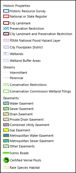
The "Permitting Information" view shows features that may affect the permitting process. Expanding this selection will show the individual layers inside, each can be turned on or off with the eye symbol.
Hover over the "Map Legend" to see what the colors and patterns in the Permitting layers represent.
Data Sources:
Data are from the Newton Geographic Information System (GIS)
The Base Map is compiled and updated byEsri with most of the features provided by the City of Newton.
Permitting Information:Wetlands are fromMassGIS(Bureau of Geographic Information)
FEMA Flood Zones are from the FEMAFlood Insurance Rate Maps, effective June 4, 2010.
Aerial Photography:
City of Newton, April-May, 2015
Specific information about any GIS data layer can be found on the Newton GISData Dictionary page.
